2016-05-08 (Sunday)

Today, I learned that:

Exactly 71 years ago, the World War II ended in Europe. And on the 25-year celebrations on 1970-05-08, I was in Berlin for the first time, together with colleagues and teachers in the final month of elementary school.

It was a fascinating journey, with ferry from Trelleborg to Sassnitz, and from there train through East Germany to West Berlin. One day, we took the S-Bahn into East Berlin and transposed the Berlin Wall. Once there, a colleague and I interviewed people on the streets about life in the East! And on the very day of the war end anniversary, there were of course heavy demonstrations about the current state of division of the German peoples. The following day, we also visited the Olympiastadion, where the West German football squad played against Ireland, resulting in a 2-1 win. Although the German team, coached by Helmut Schön, had top players such as Berti Vogts, Jürgen Grabowski, Wolfgang Overath, Gerd Müller, Franz Beckenbauer and Uwe Seeler, the game was a tough fight. Full details can be found in reference # 1 below.

Then it would take 37 years until I returned to Berlin. The Wall was gone, although quite some things reminded me of what had been. I went on a very interesting sightseeing tour, with guide on foot. The whole event was scheduled to take 4 hours, but we had so many interesting questions that it was prolonged for 2 more hours! Today’s header image shows Berlin’s #1 symbol, Brandenburger Tor, and below are some other photos I took that day. The memorial of the holocaust is located close to there, and just beside the place where Hitler had his ultimate bunker. Seeing those stones, to signify all the people exterminated in the concentration camps, made a deep and very distressing impression on me. See also the other references below for more details about the most interesting city, and I dare to say, Europe´s de facto capital, Berlin.

Berlin25

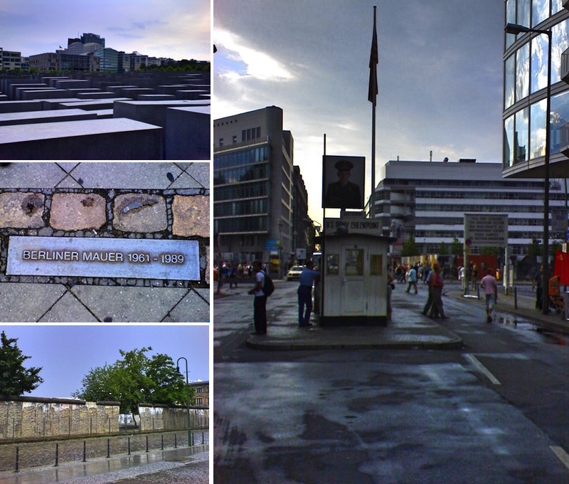
4 photos I took on 2007-06-09. In the left column, from top to bottom: – The holocaust memorial; – A plate showing where the Berlin Wall used to divide the West and the East during more than 28 years; – Part of the original Berlin Wall. In the right column: Checkpoint Charlie, the famous crossing between West and East Berlin.

Finally, although I am not very fond of the American way of life, I must admit there are many interesting, creative people there. The web site CreativeLive is paying a tribute to some of them, through a series of video interviews, during the month of May, called 30 days of Genius. See reference # 6 below with a link to a subscription to the series, free of charge.

… That’s what I learned in school !

Refs.:

1: West German football team defeated Republic of Ireland 2:1, 9 May 1970

2: Brandenburger Tor

3: Holocaust memorial

4: Berlin Wall

5: Checkpoint Charlie

6: 30 days of Genius

+: What did you learn in school today ?

2016-01-26 (Tuesday)

Today, I learned that:

The custom of numbering the houses on a street, in order to facilitate visits, delivery of mail and parcels, etc., is said to have started in 1512, when there was built a new bridge in Paris, Pont Notre-Dame. On the bridge were built 68 equal houses and in order to distinguish one from another, they were given golden numbers on the outside, with odd numbers on one side and even numbers on the other side of the bridge. Initially, the purpose of this numbering was not so much to find the house for a visit, but sort of registration of property.

Pont Notre-Dame

La Joute des mariniers entre le Pont-Notre-Dame et le Pont-au-Change, painted by Nicolas-Jean-Baptiste Raguenet in 1752.

Today, practically all towns and cities have a numbering system, although there are differences. The article in Wikipedia, referenced below, deals with the numbering in most parts of the world, so I will not repeat it, but recommend it if you are interested in knowing further details. Here, I will only give some bullet points and also complement that article with some interesting pieces of information.

The basic rule is that the numbering starts in some place with high importance to the city, e.g. City hall, Main cathedral, etc. So the point of the street that is closest to this reference point receives the lowest number and the numbering then increases when you move away from the reference point. It is also very common that one side of the street, normally the left side, receives odd numbers and the other (right) side gets even numbers, just like in Paris in 1512. However, there are exceptions, where the odd numbers are used on the right side and even numbers on the left side.

The distribution of the numbers can be either sequential or by distance. The traditional, sequential distribution, such as 1, 3, 5, 7, 9, 11, … only indicates the relative position of a certain building compared to the reference point and other buildings on the same side of the street, but does not necessarily include information about the distances involved. This type of distribution is prevalent in Europe and many of its former colonies.

However, a different number distribution is very common in USA and Canada. It is basically the same as for sequential distribution, but usually all numbers are not present. The increase in the number used on a building, when compared to its neighbour located closer to the reference point, signifies roughly the distance (in yards) between the two. This distribution system goes hand in hand with the distribution of houses in blocks, and where each new block starts with a multiple of 100. Of course this means that it is easier to know how big is the distance still to be covered to the desired building, merely subtracting one number from the other.

Yesterday, I wrote about São Paulo, and since Brazil is not covered in this Wikipedia article, let me complement it with some information also from Brazil. The predominant system here is similar to the one used in North America, except that the distance is measured in meters, since Brazil uses the SI system. However, there are some Brazilian cities that use the sequential distribution, e.g. Santos, which celebrates its birthday today, being founded on January 26, 1546. However, the 8-year younger city, São Paulo, uses the distribution by distance, where most of the streets rely on Praça da Sé, the city center, as the reference point. However, in the Southern Zone of São Paulo, that until 1935 was the autonomous city of Santo Amaro, the numbering starts at the Cathedral of Santo Amaro.

… That’s what I learned in school!

Refs.:

1: House numbering

+: What did you learn in school today ?

2016-01-25 (Monday)

Today, I learned that:

There may still be hope for humanity. Even if there is big doubt if we will be able to slow down the global warming sufficiently, at least it seems that we are starting to take control over the growth in population. Let me start my reasoning in São Paulo, the biggest city in South America:

São Paulo celebrates it 462nd anniversary today with a local holiday. It was founded on January 25, 1554, under the name of São Paulo dos Campos de Piratininga, by a college of twelve Portuguese jesuit priests, the most well known being Manuel da Nóbrega and José de Anchieta. In 1560, It was renamed Vila de São Paulo, belonging to the Captaincy of São Vicente, whose main village was Brazil’s first one, founded in 1532. The coming centuries did not contribute much to history, but in 1711 São Paulo was converted from town to city. However, there were still few people living in the city. In 1872, there is an information that the population amounted to only 31.385 inhabitants. But from that point on has been a steep slope upward, with the current official number being 11.316.149 inhabitants (2011), and an estimate from the national statistics agency IBGE of 11.967.825 inhabitants in 2015.

In order for us to see the evolution of São Paulo from a village to one of the biggest cities in the world, let us look at the following table, which compares the growth of the population of São Paulo and the entirely world:

growthrate

As you can see, the current population growth rates are the lowest recorded during the last two centuries, so I believe it is a good sign that the world population will be able to take care of itself for quite some time yet.

Paulista++

Avenida Paulista, São Paulo, October 14, 1990

Returning to São Paulo, where I lived during 19 years old, and where both of my children were born: What can be more typical than characterizing them as “paulistas” (from the state of São Paulo), “paulistanos” (from the city of São Paulo), born on the biggest street Avenida Paulista (which also serves as a background to the photo above of my parents, taken in 1990), and, hopefully, also “são paulinos” (fans of São Paulo Football Club).

Finally, today is also the birthday of my sister-in-law Sônia, お誕生日おめでとう!

… That’s what I learned in school.

Refs.:

1: São Paulo on Wikipedia

2: São Paulo no IBGE

3: Population growth

4: World population

5: São Paulo FC

+: What did you learn in school today ?

2016-01-20 (Wednesday)

20000503c

Christ Statue, Corcovado, Rio de Janeiro

Today, I learned again, that:

Rio de Janeiro is scheduled to host the 31st Summer Olympic Games later this year. But how was it that the city got its name and what does it mean?

Rio de Janeiro literally means the January River. The reason is that when the Portuguese explorer Gaspar de Lemos discovered the Bay of Guanabara on January 1, 1502, the Portuguese word for both river and bay was ‘rio’, and hence the origin of the name. When the city was founded by Estácio de Sá on March 1, 1565, its name was designated as São Sebastião do Rio de Janeiro, as a tribute also to the ruling Portuguese king, D. Sebastião.

Every city in Brazil has a day once a year when they pay a tribute to their patron saint, and when there is a local holiday. In the case of Rio de Janeiro, in consequence with what was said above, it is Saint Sebastian, and since his day is January 20, today is a local holiday in Rio de Janeiro, as well as in many other Brazilian cities, that also venerate Saint Sebastian, e.g. São Sebastião (state of São Paulo), Paranavaí (state of Paraná), Paraisópolis (state of Minas Gerais), as well as some other 250 cities all over Brazil.

… That’s what I learned in school!

Refs.:

1: https://en.wikipedia.org/wiki/Rio_de_Janeiro

2: https://en.wikipedia.org/wiki/Saint_Sebastian

3: https://pt.wikipedia.org/wiki/São_Sebastião#Brasil

+: https://www.youtube.com/watch?v=VucczIg98Gw